

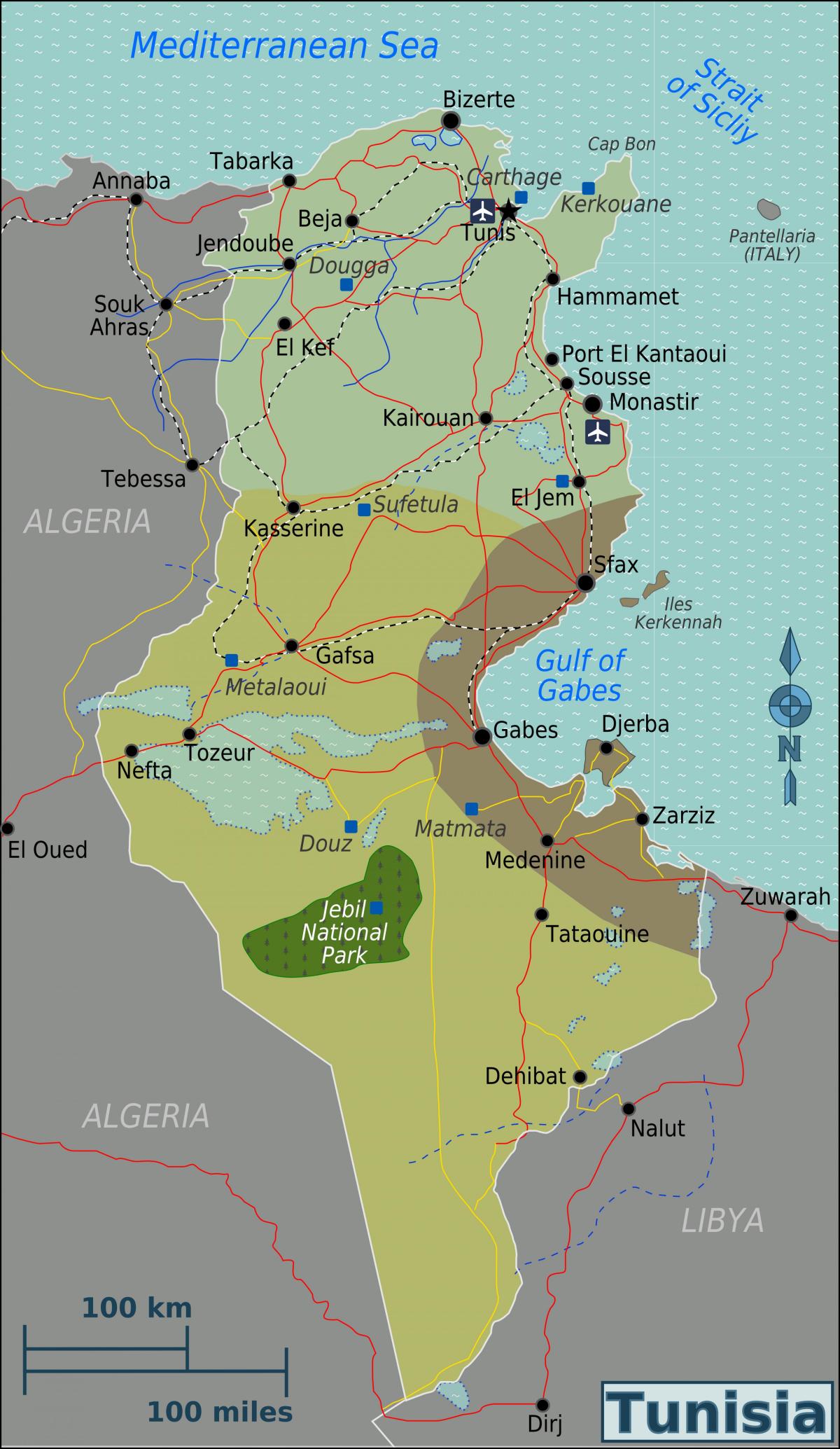
You can find on this page the Tunisia region map to print and to download in PDF. The Tunisia political map presents states, regions, provinces and surrounding areas of Tunisia in Northern Africa.

The Tunisia regions map shows surrounding areas and provinces of Tunisia. This administrative map of Tunisia will allow you to know regions of Tunisia in Northern Africa. The Tunisia regions map is downloadable in PDF, printable and free.
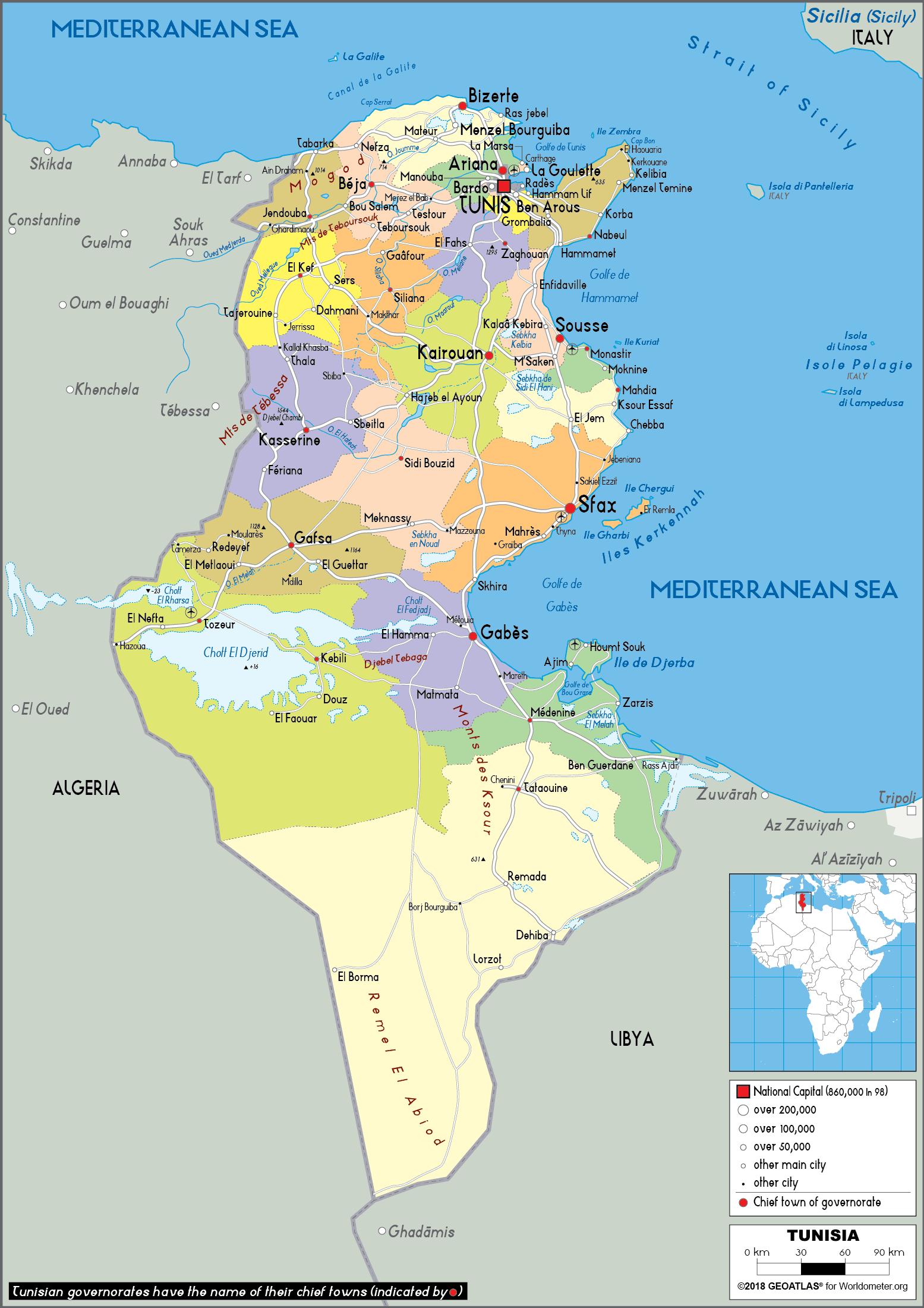
North-East Tunisia or in (Arabic Language: الشمال الشرقي التونسي ) is one of the six geographic and economic regions of the country, it consists of Seven governorates : Bizerte, Tunis, Aryanah, Menouba, Ben Arous, Zaghouan and Nabeul. The North-East region is located in the extreme north of the country, bounded to the west by the Northwest Governorate of Béja and to the North and East by the Mediterranean Sea, in South with the Central East Region as you can see in Tunisia regions map. There are Four national parks in the North-East, three of them are entirely in the region and one are partially in it: Boukornine National Park is Between the Tunis Governorate and Ben Arous Governorate, second we find Ichkeul National Park in the Bizerte Governorate third comes Jebel Chitana-Cap Négro National Park between Bizerte Governorate and Béja Governorate Finally Zembra National Park which is an Archipelago of two main islands Zembra island and zembreta island we find it in Nabeul Governorate.
The North West region is located in the extreme north of the country, bounded to the west by the Tunisian-Algerian border and to the east by Grand Tunis and the North East region as its shown in Tunisia regions map. North West Tunisia or in (Arabic : الشمال الغربي التونسي ) is one of the six geographic and economic regions of Tunisia, it consists of four governorates : Béja, Kef, Siliana and Jendouba. There are three national parks located wholly or partly in the North West: El Feidja National Park in Jendouba, Jebel Serj National Park shared between Siliana and Kairouan and the Jebel Chitana-Cap Négro National Park divided between Béja and Bizerte. Greater Tunis (Arabic: تونس Tūnis) is the capital of both the Tunisian Republic and the Tunis Governorate. It is Tunisia largest city, with a population of 728,453 as of 2004; the greater metropolitan area holds some 2,412,500 inhabitants.
In 2019, the Center-East region of Tunisia, which includes the cities of Sousse, Monastir, Mahdia, and Sfax, registered the highest number of marriages in the country, corresponding to over 19 thousand. The district of Tunis, the capital city, followed with approximately 17.6 thousand marriages in the same year. The Southwest region, the area of Gafsa, Tozeur, and Kébili, recorded the lowest number of marriages. South East Tunisia is the region in Tunisia which contains three of the country governorates: Gabes, Medenine and Tataouine as its mentioned in Tunisia regions map. The south east of Tunisia has maintained an image of moderate conservatism unlike many other regions (North and coast) which have embraced a European-like lifestyle. Inhabitants of the south east have their unique accent, social norms and a distinctive folklore.
The Tunisia political map shows regions and provinces of Tunisia. This administrative map of Tunisia will allow you to show regions, administrative borders and cities of Tunisia in Northern Africa. The Tunisia political map is downloadable in PDF, printable and free.
The politics of Tunisia function within a framework of a democratic constitutional republic, with a President serving as head of state, Prime Minister as head of government, a bicameral legislature and a court system influenced by French civil law. Between 1956 and 2011, Tunisia operated as a de-facto single party state, with politics dominated by the secular Constitutional Democratic Rally (RCD) under former Presidents Habib Bourgiba and then Zine el Abidine Ben Ali. However, in 2011 a national uprising led to the resignation of the President and the dismantling of the RCD, paving the way for a multi-party democracy. Tunisia is a member of the Arab League, the African Union and the Organisation of Islamic Cooperation as its shown in Tunisia political map. It maintains close relations with France and the European Union, with which it entered an Association Agreement in 1995. Tunisia favorable relations with the European Union was earned following years of successful economic cooperation in the private sector and infrastructure modernization.
Since 1987 Tunisia has reformed its political system several times, abolishing life-term presidencies and opening up the parliament to opposition parties. The number of new political parties and associations has notably increased since the beginning of Ben Ali presidency in 1987. Currently there are eight recognized national parties, six of which hold national legislative seats as you can see in Tunisia political map. Since his accession to the Presidency, the President party, known as the Constitutional Democratic Rally (RCD), rallied majorities in local, regional, and national elections. Although the party was renamed (in President Bourguiba days it was the Socialist Destourian Party), its policies were still considered to be largely secular and conservative. However, the Tunisian Revolution in 2011 saw its removal from power.
The Tunisian national elections of 2009 was criticized by opposition parties and some international observers for limitations placed on non-incumbents. In one instance, the Ettajdid party weekly publication, Ettarik al-Jadid, was seized by authorities for violating campaign communications laws. Meanwhile, a delegation from the African Union Commission praised the election for taking place with "calm and serenity" Prior to the 2009 election, Tunisia amended its constitution to allow more candidates to run for president, allowing the top official from each political party to compete for the presidency regardless of whether they held seats in parliament. Tunisia has recently shown interest in improving its information policy, hosting the second half of the United Nations-sponsored World Summit on the Information Society in 2005 as its mentioned in Tunisia political map, which endorsed the freedom of the internet as a platform for political participation and human rights protection.
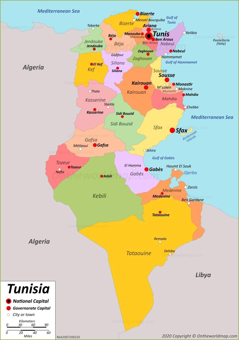
The Tunisia states map shows all departments and regions of Tunisia. States map of Tunisia will allow you to know areas and cities of Tunisia in Tunisia. The Tunisia states map is downloadable in PDF, printable and free.
Tunisia is divided into 24 governorates or states (wilayat, sing. wilayah) as you can see in Tunisia states map: Ariana, Béja, Ben Arous, Bizerte, Gabès, Gafsa, Jendouba, Kairouan, Kasserine, Kebili, Kef, Mahdia, Manouba, Medenine, Monastir, Nabeul, Sfax, Sidi Bouzid, Siliana, Sousse, Tataouine, Tozeur, Tunis, Zaghouan. The governorates are divided into 264 "delegations" or "districts" (mutamadiyat), and further subdivided into municipalities (shaykhats), and sectors (imadats). Ariana Governorate (Arabic: ولاية أريانة Wilāyat Aryānah pronounced [ærˈjæːnæ]) is one of the twenty-four governorates (provinces) of Tunisia. It is situated in northern Tunisia. The capital is Aryanah. Béja Governorate (Arabic: ولاية باجة Wilāyat Bājah pronounced [ˈbæːʒæ]) is one of the twenty-four governorates of Tunisia. It is situated in northern Tunisia. It covers an area of 3,558 km². Ben Arous Governorate (Arabic: ولاية بن عروس Wilāyat Bin ‘Arūs pronounced [bɪn.ʕæˈruːs]) is one of the twenty-four governorates of Tunisia. It is situated in northern Tunisia. It covers an area of 761 km².
Bizerte Governorate (Arabic: ولاية بنزرت Wilāyat Binzart pronounced [bɪnˈzɑrt]) is the northernmost of the 24 governorates or states of Tunisia. It is situated in northern Tunisia. It covers an area of 3,685 km². The capital is Bizerte. The offshore Galite Islands are part of the governorate. Gabès Governorate (Arabic: ولاية قابس Wilāyat Qābis) is one of the 24 governorates of Tunisia. It is located in south-eastern Tunisia as its shown in Tunisia states map. It covers an area of 7,175 square kilometres (2,770 sq mi). Gafsa Governorate (Arabic: ولاية قفصة Wilāyat Qafṣah pronounced [ˈɡɑf.sˤɑ]) is one of the 24 governorates of Tunisia. It is situated in central Tunisia, bordering Algeria. It covers an area of 8,990 km². Jendouba Governorate (Arabic: ولاية جندوبة Wilāyat Jandūbah pronounced [ˌʒænˈduːbæ]) is one of the twenty-four governorates (provinces) of Tunisia. It is situated in northern Tunisia, bordering Algeria. It covers an area of 3,102 km².
The Kairouan Governorate (Arabic: ولاية القيروان) is one of the twenty-four Governorates (states) of Tunisia. It is an inland province, situated in the centre of the country. Kasserine Governorate (Arabic: ولاية القصرين Wilāyat al-Qaṣrayn pronounced [ɡasˤˈriːn]), sometimes spelt Casrein, is one of the twenty-four governorates (provinces) of Tunisia. It is situated in west-central Tunisia on the frontier with Algeria as its mentioned in Tunisia states map. It covers an area of 8,066 km². Kebili Governorate (Arabic: ولاية قبلي Qibillī pronounced [ˈɡbɪl.liː]) is the second largest of the 24 governorates (provinces) of Tunisia. It is situated in south-western Tunisia, bordering Algeria. It covers an area of 22,084 square kilometres (8,527 sq mi). Kef Governorate (Arabic: ولاية الكاف Wilāyat al-Kāf pronounced [lkæːf]) is one of the twenty-four governorates of Tunisia. It is situated in north-western Tunisia, bordering Algeria. It covers an area of 4,965 km².